Landstown Boundaries
The four neighborhoods of Bernard Farms, Landstown Lakes, Landstown Meadows, and Woods of Piney Grove are generally bounded by Holland Road, Dam Neck Road, and Princess Anne Road. To our south are large areas of trees and undeveloped land that are rapidly disappearing as development continues.
Our location makes understanding the city's planning and development policies particularly important. District 2 is represented by Barbara Henley, whose district includes our communities and significant areas of southern Virginia Beach. Her position on development and growth is an important matter for residents to understand and monitor, particularly as development continues to move toward our neighborhoods.
As best as I remember, the names and boundaries of our four neighborhoods were established by developers as the communities were built. The City of Virginia Beach uses these subdivision designations when managing infrastructure, development, zoning, and future planning.
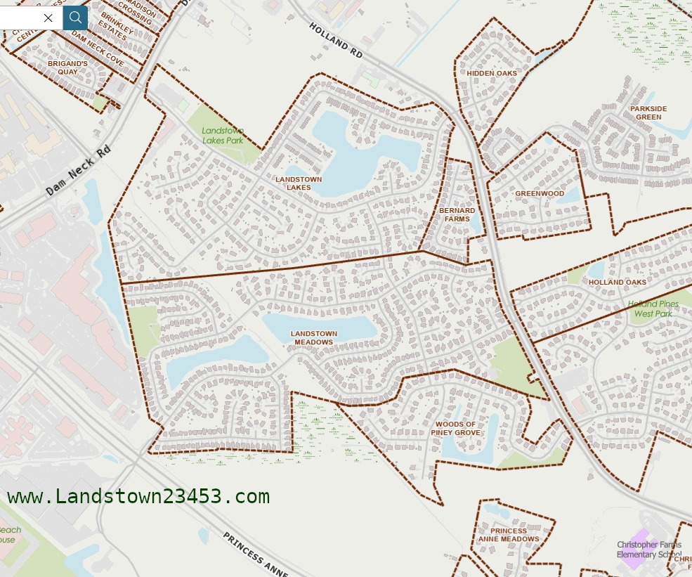
When dealing with city planning, zoning, development proposals, or infrastructure issues, knowing the city's official designation for your neighborhood can make it easier to identify the correct information and communicate with city officials.
It can also be useful when dealing with law enforcement or other city services. In some situations, police or city personnel may ask which community you live in, so knowing the official name of your neighborhood is helpful.
Green Line, Blue Line and ITA Boundaries
Understanding the Green Line, Blue Line, and Interfacility Traffic Area (ITA) is especially important because these boundaries have shaped how Virginia Beach manages growth and development.
Landstown is located north of the Green Line, placing our communities within the city's urbanized area where substantial development has historically been permitted. Because of this location, residents should expect continued pressure for residential, commercial, and infrastructure development in and around our communities.
Rapid growth and overdevelopment can create challenges, including increased traffic, noise, congestion, pressure on public safety resources, loss of trees and open space, and other changes that can affect our quality of life.
The Green Line
The Green Line is an important urban-growth boundary in Virginia Beach. Established in 1979, it was intended to help distinguish the city's urbanized area from the southern portion of the city where agricultural and rural land would receive greater protection.
Generally speaking, development is concentrated north of the Green Line, while the area south of it has historically been subject to greater protections intended to preserve open space, agriculture, and the rural character of southern Virginia Beach.
For Landstown residents, this matters because we are on the developed side of this boundary. As development continues in surrounding areas, residents should pay close attention to proposed rezonings, subdivisions, road projects, and other changes that could affect our neighborhoods.
The Blue Line
The Blue Line is another important planning boundary. It is located farther south than the Green Line and is associated with the city's public-utility and growth-management policies.
The Blue Line helps establish where urban infrastructure and utilities can be extended as part of the city's overall growth-management strategy. It therefore plays an important role in limiting the outward expansion of urban development into rural and agricultural areas.
The Interfacility Traffic Area (ITA)
A 25-year master plan and special zoning overlay district in Virginia Beach, located between Naval Air Station Oceana and Naval Auxiliary Landing Field Fentress. Because it sits directly under heavy military jet flight paths, traditional residential housing is restricted. The city focuses use on industrial expansion, municipal operations, and sports tourism.
The Transition Area / ITA
The area between the Green Line and Blue Line is commonly referred to as the Transition Area and is associated with the Interfacility Traffic Area (ITA).
This area serves as a transition between the more heavily developed urbanized portion of Virginia Beach and the agricultural and rural areas farther south. Development in this area has generally been intended to occur at lower densities than in the urban core, helping provide a buffer between suburban development and the city's agricultural economy.
Why These Boundaries Matter to Us
These boundaries may sound like technical planning terminology, but they have a direct connection to our neighborhoods.
Landstown's position north of the Green Line means that development pressure is unlikely to disappear. As residents, we need to understand where development can occur, what the city's planning policies allow, and how proposed projects could affect traffic, public safety, infrastructure, trees, noise, and our overall quality of life.
That knowledge gives residents a better ability to participate in the planning process.
We should not wait until construction equipment arrives before becoming involved. By then, many of the important decisions may already have been made.
Knowing our boundaries means knowing what is happening around us. Knowing the city's growth policies means understanding what may happen next. And staying organized gives our communities a stronger voice when those decisions are being made.
Voting
Voting Precinct - Precinct 062
In Virginia Beach, Landstown corresponds to Precinct 062 (Landstown) for voting, which typically uses the Landstown Community Church (Restoration Church at Landstown) on Monet Drive as its polling place.
Local Elections
City Council District for Landstown - District 2
Not to be confused with our U.S. Congressional District (below).
State Elections
Virginia House of Delegates (HoD) District - District 098
The Virginia House of Delegates is the lower chamber of the Virginia General Assembly, the state's lawmaking body. Together with the state Senate, it creates laws, sets state spending, and approves the state budget.
State Senate District - District 019
The Virginia State Senate is the upper chamber of the Virginia General Assembly, forming the legislative branch of the state government alongside the House of Delegates. It is composed of 40 senators who each represent roughly 215,000 citizens and meet at the Virginia State Capitol in Richmond.
Federal Elections
U.S. Congressional District - District 2
U.S. Senators
All states have two Senators elected to the United States Senate.
Police/ Fire
Virginia Beach Police Department (VBPD) Precinct - 1
Virginia Beach Fire Department (VBFD)
The Landstown area in Virginia Beach is primarily covered and served by nearby units from the Virginia Beach Fire Department, specifically utilizing response zones close to Green Run (Station 18) and Princess Anne (Station 5).
Schools
School Locator
These are the public schools serving the Landstown area in Virginia Beach. Please note that not all students may attend these schools due to zoning and other factors.
- Landstown Elementary School (Grades PK-5)
- Christopher Farms Elementary (Grades PK-5)
- Landstown Middle School (Grades 6-8)
- Landstown High School (Grades 9-12)
Garbage
Trash & Recycling information for Virginia Beach can be found on the following links:
- Virginia Beach Trash & Recycling
- "Find My Trash Day" (Located on lower left side of webpage.)