How Water Flows & How to Minimize Flooding
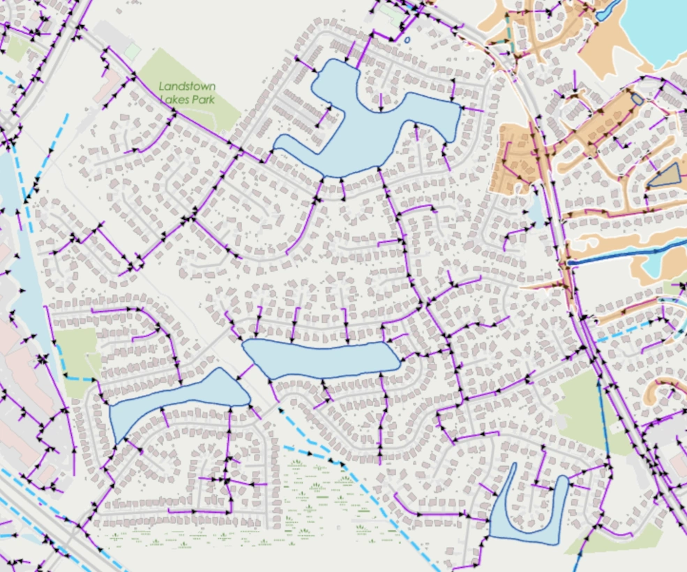
The elevation in Landstown Lakes, Landstown Meadows, Bernard Farms and Woods of Piney Grove slopes down from about 12 feet on the west side to 8 feet going east as you approach the West Neck Creek. That would explain portions of the flow of stormwater that is piped from the Winterberry ponds to the Monet Dr pond and then out West Neck Creek - west to east. The ponds are at about 4 feet in elevation. The average elevation of all of Virginia Beach is 12 feet.
Our soil type was created eons ago from lagoons that formed from silt or loam depending on the type of soil. The majority of our soil is Acredale. As you move east, a small portion changes to Tomotley soil which then transitions to Nawney silt loam on both sides of the creek. Both types of soil in Landstown drain poorly. On a sidebar, remember that our ponds can silt up just like the lagoons if we don't take care of them. We don't need eons because we unfortunately deposit debris into the lakes ourselves.
The above also explains the direction our stormwater flows and the requirement for the water to flow freely because Landstown's soil drains poorly, and is only 12 feet above sea level. If the stormwater infrastructure is blocked, we could get recurring flooding. I witnessed that in the past, as fish swam in the street, when a major choke point broke on Monet Dr. The stormwater system was also neglected so it went from disrepair to broke.
Factoring in future sea level rise will make things more precarious. As mentioned, the ponds are 4 feet above sea level. If there is a 3 feet increase in sea level by 2050 ~ 2080, the ponds would be only 1 foot above sea level.
It's no coincidence that two major choke points in Landstown happen to be in flooding zones. One is the discharge out of the Monet Dr pond to West Neck Creek and the other is near Winterberry and Holland which has critical discharge points (that converges) for Landstown, Bernard Farms and Woods of Piney Grove.
What is important to note is that they discharge into a ditch before traveling to the creek (see map). With that said, our soil type drains poorly and ditches not only carry water but also help lower the water table. It is important to keep all ditches large and small clear and properly maintained! It's also important to keep debris out of our stormwater system.
With that said, there is an important second lesson: ditches are infrastructure. They don't merely carry stormwater; in areas with poorly draining soils, they can also provide an important pathway for lowering the local water table. Keeping them free of trash, vegetation overgrowth and other obstructions is part of maintaining the community's flood protection.
- Southern Rivers Watershed of Virginia Beach
- Landstown Google Map
- Sea Level Rise Viewer
- Drought Region Advisory Map
Remember that for the most part, water flows east towards the river. That will help you understand a little better how the drainage system works
What Residents Can Do
- Keep debris out of storm drains and drainage ditches.
- Report blocked or damaged stormwater pipes and structures.
- Report broken grates, erosion and significant drainage problems.
- Don't assume a ditch is insignificant—it may be an important part of the larger drainage system.
- Pay particular attention to drainage problems after major storms, when restrictions can become much more consequential.
In Virginia Beach, report damaged storm pipes, broken grates, erosion, or major drainage issues to the Department of Public Works Operations.